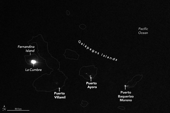
Fernandina, the youngest of the Galápagos islands, is known for being the most volcanically active. Located on a mantle plume that produced all of the Galápagos islands, the island’s La Cumbre volcano erupts roughly every four years. The most recent eruption began on March 2, 2024, with lava flowing from a circular fissure on the volcano’s southeast flank.
Satellite images captured the eruption’s glow on March 5, showing the intensity of the event. Fernandina, the third largest island in the Galápagos archipelago, lies approximately 1,100 kilometers off the west coast of Ecuador. Lava spilled down the peak of the volcano, creating a striking visual of the natural phenomenon.
Monitoring the eruption from above, Sentinel-1 satellites detected land surface inflation in the volcano’s caldera, indicating magma movement. Abundant thermal anomalies were observed, signaling the movement of lava flows. Sulfur dioxide emissions increased but decreased steadily after the initial eruption, a common pattern in effusive eruptions.
Galápagos volcanoes like Fernandina are known for their rich sulfur dioxide emissions and low ash production due to the low viscosity basaltic magma. Despite the volcanic activity, the eruption seems to be more prolonged than recent events, providing a spectacle for onlookers on passing ships.
While Fernandina is uninhabited and lacks infrastructure at risk, it is home to a diverse population of rare land iguanas. These reptiles, along with other animals on the island, depend on the ecosystem that has been shaped by volcanic activity over the years.
Geologists are closely monitoring the eruption using both aerial and ground-based sensors to understand the event better. The combination of remote sensing and ground-based networks provides valuable insights into the volcanic activity on the island. The ongoing eruption of Fernandina continues to captivate both scientists and nature enthusiasts alike.


